The details of the 2021 Nyiragongo eruption using infrasound
Last modified: December 10, 2025 | First published: December 01, 2025
In a study published in Nature Communciations Earth & Environment in November 2025 we show the power of infrasound as a crucial monitoring tool, complementing other monitoring techniques such as seismic or satellite measurements.
In the case of Nyiragongo’s eruption in 2021, the infrasound measurements provided unprecedented insights into the timing of fissure openings on the volcanic flank, and allowed for providing detailed constraints on the processes underlying the lava lake drainage during the eruption.
Eruptions at continental basaltic volcanoes can take and combine various forms, including lava lakes, lava flows and fountaining, explosions or structural collapses. Recording seismicity is widely recognized as essential for tracking magma movements at depth but must be complemented with other observations for monitoring eruptions, which are by essence atmospheric processes. Aside from a few well-instrumented cases worldwide, accurately reconstructing the precise eruptive mechanisms and chronology is hampered by the lack of detailed visual observations in space and time. Because they emit low-pitched inaudible sounds, called infrasounds, any changing and potentially hazardous eruptive activity can be inferred with specialised microphones.
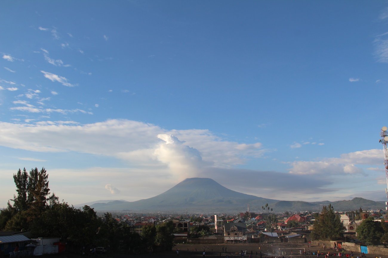
On 22 May 2021, the drainage of Nyiragongo’s long-lived lava lake in D.R. Congo was accompanied by lava flows from eruptive fissures toward a one-million urban area composed of the cities of Goma (D.R. Congo) and Gisenyi (Rwanda). After 1977 and 2002, this was the third known flank eruption and the first one adequately monitored with seismic and geodetic instruments to understand magma movements at depth. A probable scenario supported by these geophysical observations is the rupture of the edifice, starting around 15:57 UTC, draining the lava lake and initiating a week-long magmatic intrusion (dyke) in the Earth’s crust. Infrasound records from local distance (< 20 km) are converted, using acoustic numerical modeling, into high-resolution time-lapse observations of the catastrophic drainage of the world’s largest lava lake at that time.
The emitted infrasounds also enable tracking of fissure openings and lava eruptions along the flank, occurring simultaneously with the lava lake drainage. This striking example highlights how decoding each specific volcano’s acoustic signature provides unique information inaccessible to other ground-based instruments, which can be integrated to monitoring and multi-hazard early warning systems.
- Source: Barrière, J., Oth, A., Assink, J. et al. Infrasound reveals detailed eruptive processes at Nyiragongo volcano and enhances monitoring capabilities during unrest periods. Commun Earth Environ 6, 978 (2025). https://doi.org/10.1038/s43247-025-02937-3
- Open access to the full article: https://rdcu.be/eR5ym
Some of these processes could be measured with great fidelity even at an infrasound station in Kenya more than 800 km away from Nyiragongo, which is part of the International Monitoring System (IMS).
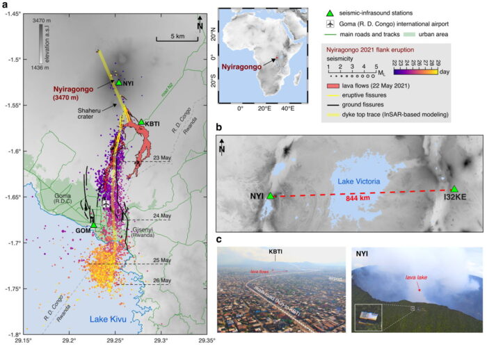
The May 2021 Nyiragongo’s flank eruption. a, Map of Africa situating Mount Nyiragongo and zoom into the study area. Local stations (KivuSNet network) with co-located seismic and infrasound sensors are depicted as green triangles. Data for the Nyiragongo 2021 flank eruption are the seismic events over time (blue to yellow from 22 to 28 May 2021, with marker size corresponding to the magnitude between 1 and 5, minimum latitudes along the path of the dyke at 00:00 UTC on 23, 24, 25 and 26 May are indicated by horizontal black dashed lines); the lava flows (red area); the eruptive fissures (yellow lines); the ground fissures detected from Interferometric Synthetic Aperture Radar (InSAR) (black lines); the dyke top trace connected to eruptive fractures (thick transparent yellow line) obtained from InSAR modelling. b, Location map of the lake Victoria (blue area in the middle), the Nyiragongo volcano (pinned by its summit station NYI) and the infrasound station I32KE (IMS) on the EAR’s eastern branch. c, Photos taken from a helicopter over the city of Goma (after the eruption on 4 June 2021) and over the summit station NYI in 2018.
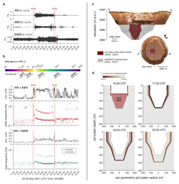
Infrasound peak frequencies from cross-correlated records and time-varying acoustic resonance model of Nyiragongo’s pit crater. a, Infrasound records filtered between 0.1 and 2 Hz at NYI, KBTI and I32KE between 11:00 on 22 May and 05:00 on 23 May. Red lines (16:30 to 22:30) indicate the time interval associated with high amplitude in time domain b, Gliding dominant frequency and high correlation coefficients between NYI and I23KE, NYI and KBTI. Note that NYI is used as reference providing a similar time stamp for correlation coefficients and peak frequencies between NYI and other stations. The colour scale represents the time lag at KBTI, GOM and I32KE with regards to an infrasound source at Nyiragongo (i.e., NYI) assuming direct propagation path and different apparent velocities (340 m/s for local stations, 290 to 310 m/s for I32KE). c, Nyiragongo’s cross-section model on 22 May 2021 before the eruption obtained from UAV-based photogrammetry model (DEM as brown surface) and from SAR-based amplitude images. Note that the diameter of the pit crater hosting the lava lake is poorly constrained below ~3.000 m a.s.l., that is along the last ~100 m of depth (bottom radii of 70 or 10 m are both represented). d, Pit-crater cross-sections corresponding to model estimates (i.e., crater’s part not filled by lava) at 16:50, 17:20, 18:20 and 22:20 plotted on the lava-lake extent (i.e., fully filled) estimated before the eruption (dotted lines). The inverted pit-crater models are coloured according to misfit (L1-norm) between observed and predicted peak frequencies expressed in octave band.
